
Affidati ad un Internet Provider affidabile:
Anyweb, a Pisa dal 1996!
The town, which lies on the southern part of the hyblaean mountains, is the capital of the province to the South of Italy, Ragusa the eleventh for altitude and is about 20 km from the sea.
The highest peak is the monte Arcibessi (906 m a.s.l.), for this is one of the municipalities bordering the sea that have the highest vertical drop.
The oldest district of the city, Ragusa Ibla, stands on a hill.
To the East the town is surrounded by the colle San Cono, and in between there flows the river Irminio, the most important of southeastern Sicily.
To the North the city is surrounded by Mount Patro, in the Valley in between there flows the river San Leonardo. To the South lies mount Bollarito which is divided from Dubrovnik via the torrent River.
Finally to the West rises Ragusa superiore colli Patro and beautiful sights, the newest part of the city instead of the hills Corrado, pendant and savage, the first two detached from the surrounding hills by two deep gorges, the typical "cave" of the planking, the quarry San Leonardo and Cava Santa Domenica.
La City developed westward until you reach the plateau (680 m a.s.l.). In the past the whole territory of Ragusa was covered by dense Mediterranean vegetation consisting mainly of Oaks and laurels. The deforestation perpetrated over the centuries, starting with those massive made by the Romans, in order to allocate the land for the cultivation of cereals and pastoralism, contributed largely to the decrease in water resources, but in the entire province are greater than those of other provinces in Sicily.
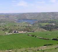
The river Irminio, once navigable, as evidenced by ancient Arabic documents, is barred by a dam, this has given rise to an artificial lake: the lago di Santa Rosalia, which is halfway between the territory of Ragusa and Giarratana. In the hyblean area flora includes over 1500 taxa, mostly belonging to the element circum-Mediterranean.
The unincorporated territory, almost all of them, it insists on the final flaps of the hyblaean mountains that gently, slide towards the sea, a plateau characterized by huge expanses, a disrupted lattice walls dotted with carob and olive trees.
The pads once degraded to the level of the sea, give way to the coast, mostly consisting of huge tracts of sand. In the last two million years, marine regression ended in miocene had left out the Iblei and the whole bottom that goes up to the maltese Islands, by contrast, movement in the pliocene dipped lower lands and the armorican submarine volcanic activity made composed the planking of Ragusa.
The terrain is hilly, consisting of large plateaus and valleys and the flow of the rivers eroded the plateau forming numerous deep canyons. The hyblean plateau is one of the promontories of the African plate and consists of a continental crust mostly carbonate sediments and Cretaceous age carbonate-Marly-Quaternary alkaline volcanics, which nest is also spread the karst. In coastal areas, near the sea, lies the sandstone.
Some areas of the hyblaean mountains are also volcanic rocks as near Monte Lauro, part of a submarine volcanic complex. From the limestone that abounds throughout, the dry stone walls that delimit the closed and that dot the landscape.
wiki source